• Welcome to Jetboaters.net!

    We are delighted you have found your way to the best Jet Boaters Forum on the internet! Please consider Signing Up so that you can enjoy all the features and offers on the forum. We have members with boats from all the major manufacturers including Yamaha, Seadoo, Scarab and Chaparral. We don't email you SPAM, and the site is totally non-commercial. So what's to lose? IT IS FREE!

    Membership allows you to ask questions (no matter how mundane), meet up with other jet boaters, see full images (not just thumbnails), browse the member map and qualifies you for members only discounts offered by vendors who run specials for our members only! (It also gets rid of this banner!)

    free hit counter

Depth maps

mraz72

Jetboaters Commander
Messages
827
Reaction score
310
Points
187
Location
Rochester, NY
Boat Make
Yamaha
Year
2016
Boat Model
242X E-Series
Boat Length
24
I am taking a trip to the 1000 islands in NY this weekend and I was wondering, when you guys go to a new place, do you look at some sort of map to get the layout of the water depths, do you use electronics (some sort of GPS with depths) or do you just scout around before going where you aren't sure?
 
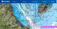
Several people have charplotters installed that will give details of the areas you are traveling which works great in strange lakes. You can also download Navionics to your phone or tablet and it can do the same thing. There's a free version and an unlimited version for $10/year I believe. Well worth it for the paid version.
 
Several people have charplotters installed that will give details of the areas you are traveling which works great in strange lakes. You can also download Navionics to your phone or tablet and it can do the same thing. There's a free version and an unlimited version for $10/year I believe. Well worth it for the paid version.

Perfect, I'll use the phone or I can dedicate my ipad mini for the trip....
 
But! DO NOT just use one source if it is unfamiliar waters... plotters alone will get u in trouble.. sometimes!
 
But! DO NOT just use one source if it is unfamiliar waters... plotters alone will get u in trouble.. sometimes!

So if I buy the navionics package for this trip, are you saying I should get a different set of maps just to compare them? Any recommendations?
 
I've only used the Navionics app. If cell coverage is spotty, be sure to download the maps locally for the area that you'll be boating in (this will also save on your data plan)
 
Thanks, I'll print out a map and use the app, great advice guys. Thanks again.
 
Once u get to know body of water one source is enough but in unfamiliar water one source alone can get u in trouble..
@PaulyB can attest to this.. his GPS ran him up on shore at night... now he has a lot of work in front of him..
 
Also take the time to review the maps with others that will be with you. My first time out I did not do this and tried having my daughter help me out but she did not know how to read it. Made a 15 min trip into a couple hrs
 
The mighty St. Lawrence River. Most of the shipping channels around Abay (1000 islands) run 50' to 250'. There are a select few shoals around that area that drop to 2'. Mostly everywhere else you will be more than ok with a jet boat. I grew up on that river boating in a 32' bayliner with a flybridge. If you get a chance, take a tour of Boldt Castle.
 
Sorry guys, not to be a PITA, but its a terminology thing, to me maps are for roads/directions on land and charts are for use on the water. I always carry a waterproof hardcopy chart of the waters I boat in. Marinas in the area should sell them, and places like a local West Marine or other boating supply store. You can also down load anything from the interweb, but it most likely will not be waterproof which should be ok for using a couple of times on vacation there.
 
A cheap fish finder is a great tool. I used to use a navionics app but deleted it when the one time payment turned into a subscription without warning. The app accuracy in my waters was poor anyway. Cam.
 
My neighbor was up there over the 4th, and even with the high water levels managed to hit a shoal, prop and skag damaged. He was just using the depth gauge on his fish finder.
 
So if I buy the navionics package for this trip, are you saying I should get a different set of maps just to compare them? Any recommendations?
I think the point is you can use the maps for reference but your eyes are the most important navigation device.
 
Navionics is what i use. You can download the app on android/apple plus you can go to their website www.navionics.com and use it for free on a desktop browser. I purchased the app and use it when ever we go to an unfamiliar lake.108417
 

That's a bummer but the article did mention they will still provide paper maps via 3rd party places so that's good for folks that prefer paper. Doesn't require a cell signal to be read or load data :). Don't get me wrong I love tech too (and use it as primary) but the old soul in me still likes paper maps and atlas to meander on :D
 
These folks know that cell service is not needed to utilize the maps if downloaded in advance. They also know that if someone wants a printed map, they do just that, print it.

Stopping printing is based on demand, and if nobody is demanding it, why print it. Especially when it's so easy to print them yourself. And for those without a color laser at home, there is a Kinkos or Office Depot close by that can print just about anything.
 
Back
Top